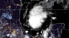
A developing storm in the Gulf of Mexico is expected to reach hurricane strength by Thursday, potentially becoming the first hurricane of a record-breakingly quiet Atlantic season. Meteorologists are closely monitoring the system's rapid intensification as it moves toward the coastline. This sudden development has caught many experts by surprise given the lack of activity earlier this year. Residents along the Gulf Coast should prepare for significant impacts. The storm's path remains uncertain, but the potential for a major hurricane is high. Local authorities are currently issuing preliminary warnings to ensure public safety remains a top priority.
How will Tropical Storm Isaias intensify?
Tropical Storm Isaias is currently on a trajectory to reach hurricane strength by the morning of Thursday, October 8, 2026. According to the US National Hurricane Center, the system is showing significant potential for further strengthening, with forecasts suggesting it could escalate to a Category 2 hurricane by Friday morning.
The storm's rapid development is being fueled by exceptionally high sea surface temperatures. Currently, water temperatures in the region are measuring between 30°C and 31°C. These warm waters provide the thermal energy necessary for tropical cyclones to intensify rapidly. While forecasters expect the storm to encounter increased wind shear as it moves northward, which may act as a natural brake on its growth, the current environment remains highly conducive to intensification.
The role of sea temperatures and wind shear
The interplay between ocean heat and atmospheric stability is critical for Isaias. While the high sea temperatures provide the 'fuel,' the upcoming encounter with wind shear represents the primary obstacle to the storm reaching higher categories. Wind shear refers to the change in wind speed and direction at different altitudes; high shear can effectively tilt or disrupt the vertical structure of a developing hurricane, preventing it from consolidating its core.
In the current scenario, Isaias has managed to form in a specific pocket where wind shear is limited despite the broader seasonal trends. This combination of low shear and very high sea temperatures—currently at 30 or 31°C—is what allows the storm to overcome the typical suppressive forces of the 2026 season. However, as the storm progresses northwards, the likelihood of encountering more significant wind shear increases, which forecasters believe should limit its ultimate intensification. The exact intensity remains subject to change as the storm's path evolves.
Where is the landfall expected to occur?
Landfall for Isaias is currently projected to occur late on Friday or early on Saturday, primarily impacting the US Gulf Coast. While the exact point of impact remains subject to shift, meteorological models suggest the storm will likely strike areas within Louisiana, Mississippi, Alabama, or Florida.
Before reaching the United States, the storm's outer bands will impact Mexico. The Bay of Campeche and the Yucatan Peninsula are expected to experience the first direct effects, with potential rainfall totals reaching 4 inches (100mm) accompanied by strong winds. As the storm moves toward the Gulf Coast, emergency preparations are already underway.
- Florida: Governor Ron DeSantis has declared a state of emergency across 25 counties due to concerns about potential impacts.
- US Coast: The US National Weather Service has issued both Hurricane and Storm Surge Watches along the Gulf Coast.
- Primary Impact Zones: The region spanning from southeast Louisiana to northwest Florida is at high risk.
What are the primary risks to coastal and inland areas?
The most immediate threats posed by Isaias include damaging winds, torrential rainfall, and a significant storm surge that could inundate low-lying coastal regions. For those living near the shoreline, the storm surge represents a critical danger, as it can cause rapid flooding in areas that are usually dry.
Inland, the risks transition from wind and surge to heavy precipitation and flooding. Forecasters anticipate the following rainfall patterns:
| Region | Expected Rainfall | Primary Risk |
|---|---|---|
| Mexico (Yucatan/Campeche) | Up to 4 inches (100mm) | Strong winds and rain |
| US Gulf Coast (General) | 3 to 6 inches (75-150mm) | Flash flooding |
| Specific Urban Areas | Up to 10 inches (250mm) | Severe flash and river flooding |
Urban environments are particularly vulnerable to flash flooding due to impervious surfaces, while rural areas face the risk of isolated river flooding as runoff accumulates. Even as the storm moves further inland and loses its warm water energy source, it is expected to remain a disruptive force, bringing wet weather as far north as the Tennessee Valley and the Carolinas.
Why has the 2026 hurricane season been so quiet?
Isaias marks a significant turning point in a season that has been characterized by a lack of hurricane-strength systems. Although Isaias is the ninth tropical storm of the 2026 Atlantic season, it is the first to reach hurricane status. This unusual trend is largely attributed to the presence of a strong El Niño pattern in the Pacific Ocean.
El Niño typically alters global atmospheric circulation, leading to increased wind shear across the Caribbean and the Atlantic Ocean. This shear acts as a destructive force, often tearing apart developing tropical disturbances before they can organize into full-scale hurricanes. Consequently, while the 2026 season has been record-breakingly quiet, Isaias demonstrates that even under suppressive conditions, high sea temperatures can allow a storm to overcome these atmospheric barriers.
Comparing El Niño impacts on hurricane activity
During El Niño years, the vertical wind shear in the Atlantic basin is generally higher than during La Niña years. This creates an environment that is hostile to tropical cyclogenesis. Forecasters had anticipated a quiet season for 2026 based on these models, making the rapid intensification of Isaias a notable deviation from the seasonal norm.
The strength of the developing El Niño is noted to be among the strongest on record, occurring weeks before the expected peak of the hurricane season. This has led to a season that has been described as eerily quiet. Isaias serves as a reminder that while El Niño lowers the odds of hurricane formation, it does not make it impossible, especially when localized conditions like extreme sea surface temperatures are present.
Frequently asked questions
Will Tropical Storm Isaias become a hurricane?
Yes, current forecasts from the US National Hurricane Center indicate that Isaias is likely to reach hurricane strength by Thursday morning. There is also a significant possibility that it will intensify into a Category 2 hurricane by Friday morning as it approaches the Gulf Coast.
Which US states are most at risk?
The US Gulf Coast is the primary area of concern, specifically parts of Louisiana, Mississippi, Alabama, and Florida. Florida has already declared a state of emergency in 25 counties due to the potential for damaging winds and storm surges in these regions.
What kind of rainfall should be expected?
The Gulf Coast could see between 3 and 6 inches of rain, with some specific locations receiving up to 10 inches. This high volume of precipitation increases the risk of flash flooding in urban areas and isolated river flooding in other parts of the south-east USA.
How does El Niño affect hurricane formation?
El Niño increases wind shear in the Atlantic and Caribbean regions. This wind shear can disrupt the structure of developing tropical storms, preventing them from organizing into hurricanes. This phenomenon is the primary reason why the 2026 season has been exceptionally quiet so far.
Will the storm affect areas far from the coast?
Yes, although the storm will weaken after moving inland and losing its warm water fuel, it will continue to bring disruptive wet weather. This weather is expected to extend as far north as the Tennessee Valley and the Carolinas.
Key takeaways
- Isaias is projected to be the first Atlantic hurricane of the 2026 season.
- The storm may reach Category 2 intensity by Friday morning.
- High sea temperatures of 30-31°C are fueling the storm's development.
- Landfall is expected on the US Gulf Coast late Friday or early Saturday.
- El Niño has contributed to an unusually quiet hurricane season so far.
The evolving threat of Isaias
As Tropical Storm Isaias moves through the Gulf of Mexico, the window for preparation is closing for residents along the US Gulf Coast. The storm's ability to overcome the suppressive effects of El Niño highlights the critical role that extreme sea surface temperatures play in modern hurricane development. While the exact landfall location and peak intensity may shift as the storm encounters varying levels of wind shear, the potential for significant flooding and wind damage remains high. Authorities continue to monitor the system closely as it transitions from a tropical storm into a formidable hurricane.